Introducing eGEO Compass GS: The Ultimate Geological Compass App for Android
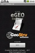
eGEO Compass GS is the ultimate geological compass app for Android, designed to simplify and enhance your field surveys. With eGEO Compass GS, you can easily measure the Dip-Azimuth and Dip-Angle of any surface without the hassle of leveling the compass. Simply lay down your phone on the plane and click "Save".
This powerful app is packed with features to assist geologists and engineers in their field work:
- User-friendly interface: eGEO Compass GS boasts a simple and intuitive design, making it easy to navigate and access all its features.
- Dip-Azimuth and Dip-Angle measurements: Measure the Dip-Azimuth and Dip-Angle of any surface with ease. No need to level the compass – simply place your phone on the plane and click "Save" for accurate measurements.
- Internal DB storage: eGEO Compass GS provides a built-in database storage system, allowing you to save and access your measurement data conveniently. This ensures your data is securely stored and easily retrievable whenever needed.
- GPS support for geo-tagging: Link your measurement data to specific geographical locations with GPS support. This is particularly useful for field surveys, enabling you to associate your measurements with precise locations on a map.
- Support for overturned (younging) measures: eGEO Compass GS goes beyond standard measurement capabilities by offering support for overturned measures. By long-pressing the "Save" button, you can capture and store data related to overturned surfaces, providing a comprehensive understanding of geological formations.
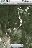
- Map preview and CVS export: Preview your measurement results on a map for a visual representation of your data. You can also easily export your measurement data in CVS format, allowing seamless integration with other software or the ability to share findings with colleagues.
In conclusion, eGEO Compass GS by GeoStru is a powerful tool designed specifically for geologists and engineers conducting field surveys. With its user-friendly interface, accurate Dip-Azimuth and Dip-Angle measurements, internal database storage, GPS support for geo-tagging, support for overturned measures, and map preview with CVS export, this app offers a comprehensive solution for collecting and analyzing geological data. Download now to optimize your field surveying experience and enhance your geological studies.


